Reality Capture for Federal Missions
A SAM-registered small business delivering survey-grade LiDAR scanning, geospatial mapping, and architectural documentation to support federal facilities, infrastructure planning, and engineering programs.
Compliance snapshot for acquisition teams
Everything a contracting officer needs in the first scroll. Detailed NAICS and PSC matrices follow below.
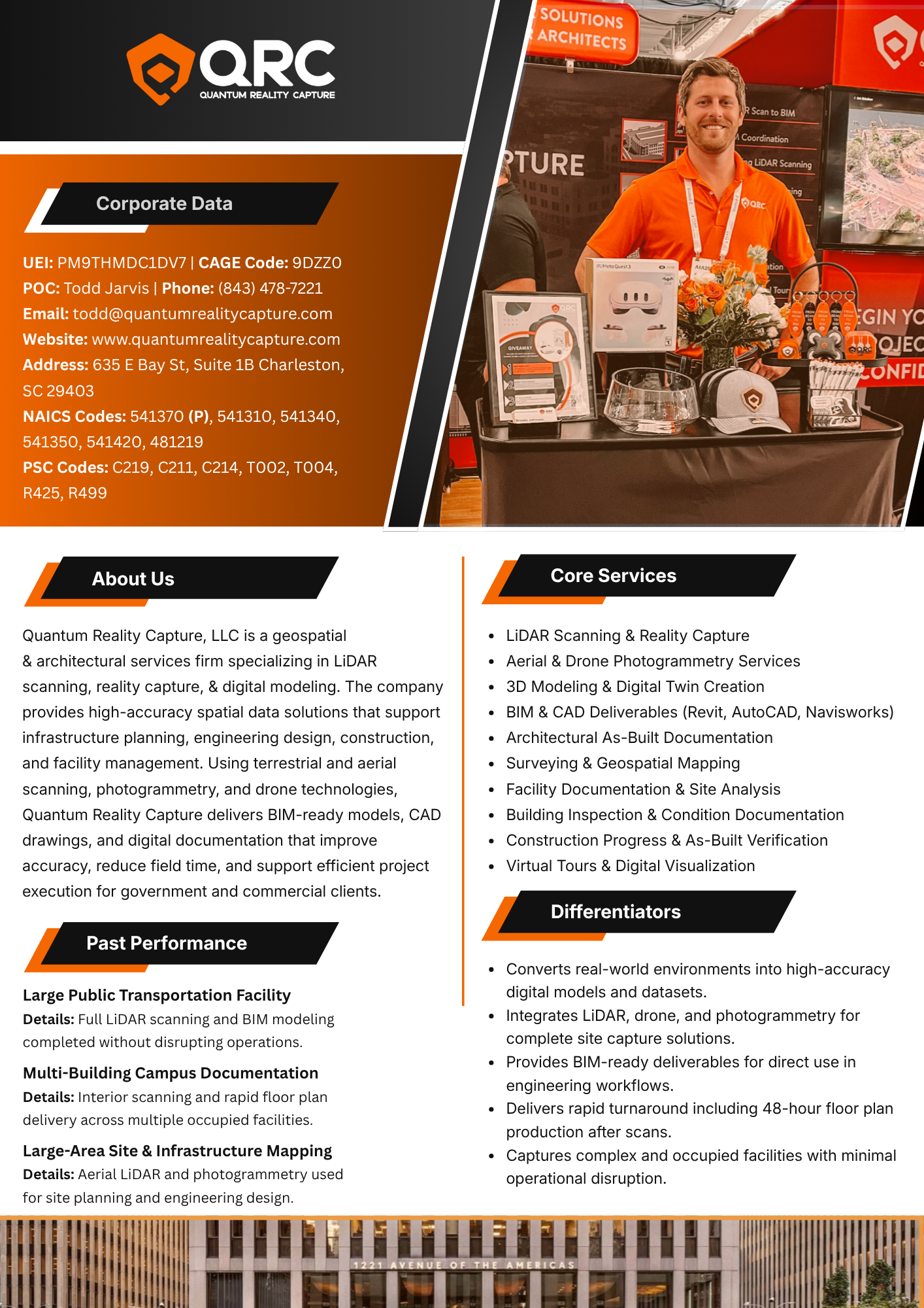
The full one-page capability statement
A single-page summary built for the way contracting officers actually read: corporate data, core services, differentiators, and recent past performance, all visible without scrolling. Print it, forward it, or attach it to an RFI response.
- Corporate data: UEI, CAGE, contacts, NAICS, PSC codes
- Company overview: geospatial & architectural services positioning
- Core services: 10-line catalog with platform notations (Revit, AutoCAD, Navisworks)
- Differentiators: 48-hour floor plan delivery after scans
- Past performance: three federal-aligned engagements documented
Translating the physical world into actionable data
Quantum Reality Capture, LLC is a South Carolina–based geospatial and architectural services firm specializing in advanced reality capture, surveying, mapping, and building documentation for government and commercial clients.
We deliver high-accuracy digital capture of physical environments using modern scanning, mapping, and design technologies that support infrastructure planning, engineering design, architecture, and facility management. Federal agencies, A/E/C primes, and facility operators rely on QRC to reduce fieldwork time, improve design accuracy, and streamline long-term documentation.
Engagements run the full spectrum: direct services to agencies, dedicated subcontractor support to primes, and embedded field teams supporting infrastructure and facility modernization programs.
Five service lines.
One field-to-finish workflow.
QRC integrates field capture, geospatial processing, and digital modeling under one team, delivering data-rich outputs that feed directly into planning, engineering, and asset-management workflows.
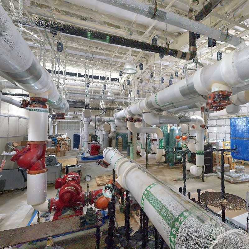
Reality Capture & Digital Site Documentation
- 3D reality capture and digital site documentation
- Building scanning and spatial data capture
- Digital twin and facility documentation support
- Existing conditions documentation
- Infrastructure documentation services

Surveying & Geospatial Services
- Land surveying support services
- Survey data collection and analysis
- Infrastructure and facility mapping
- Geospatial mapping and data development
- Survey data integration for engineering & planning

Mapping & Spatial Data Services
- Geospatial mapping services
- Site mapping and terrain documentation
- Infrastructure mapping support
- GIS-compatible spatial data production
- Engineering & construction mapping support
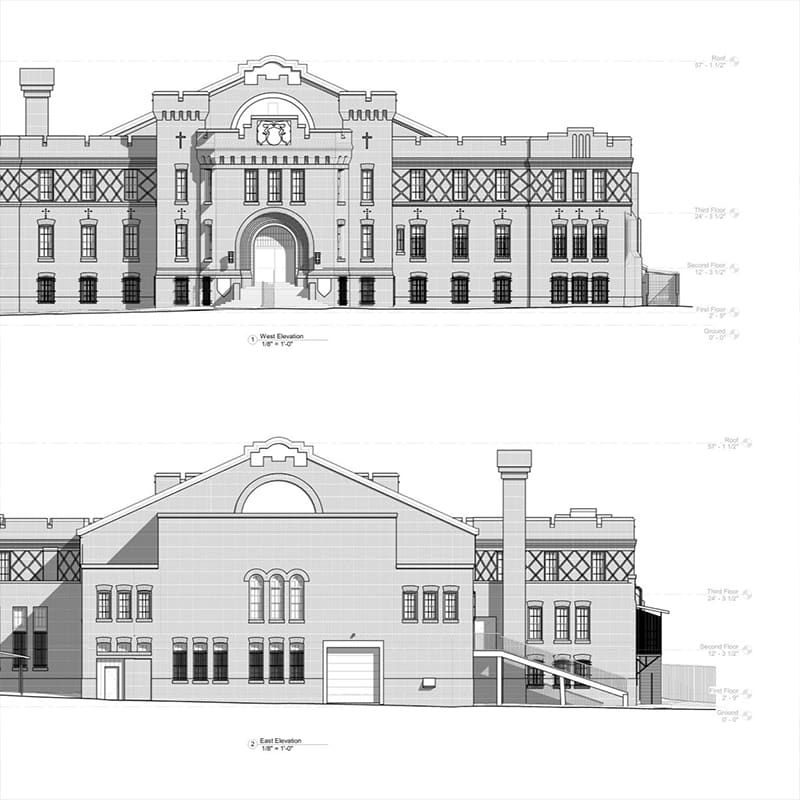
Architectural & Drafting Services
- Architectural documentation services
- Building documentation and as-built drawings
- CAD drafting and digital modeling
- Industrial design documentation support
- Engineering design support services
Building Inspection & Facility Assessment
- Facility inspection support services
- Infrastructure condition documentation
- Construction verification documentation
- Building condition assessment support
Why federal agencies and A/E/C primes partner with QRC
Six characteristics that show up consistently across the kinds of programs where reality capture has to be right the first time.
Specialized reality capture expertise
Reality capture and digital spatial documentation is our primary discipline, not a side service. We invest exclusively in scanning hardware, point-cloud workflows, and the production team behind them.
Real world → high-accuracy digital models
Existing conditions become survey-grade 3D data, georeferenced point clouds, and BIM-ready CAD deliverables that downstream teams can build from with confidence.
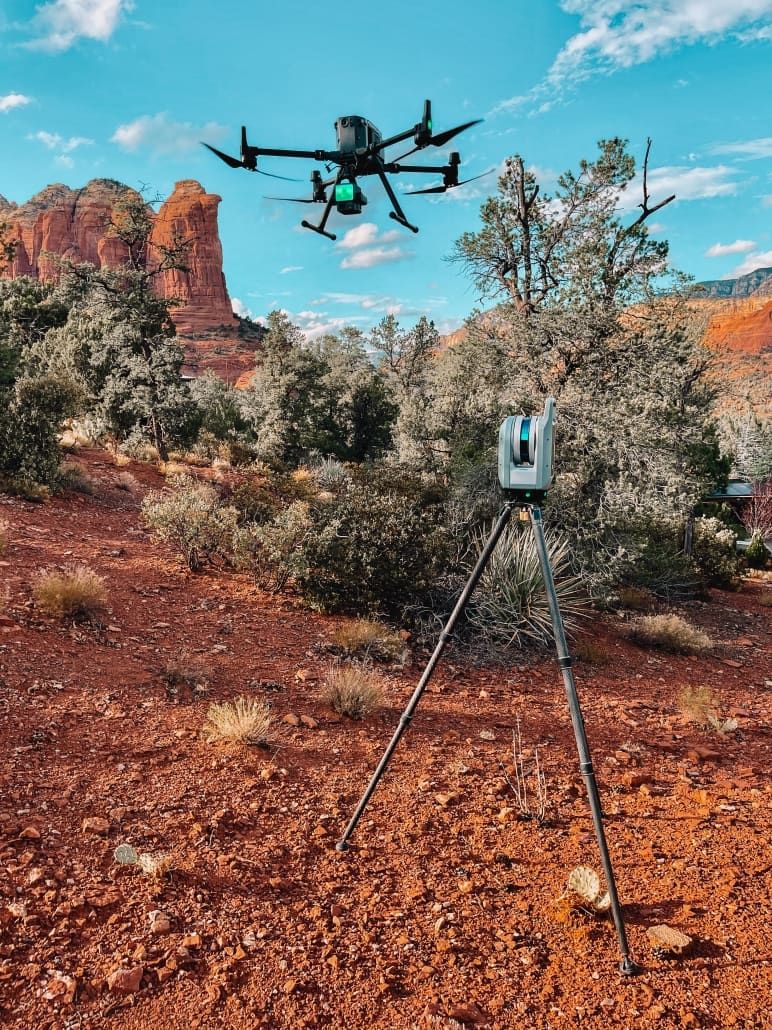
Integrated capture stack
LiDAR, drone, and photogrammetry under one team. Complete site-capture solutions without coordinating across multiple vendors or handoffs.
BIM-ready deliverables in production tools
Outputs land in the platforms your engineering teams already use: Revit, AutoCAD, and Navisworks. No translation step. No format gymnastics.
48-hour floor plan delivery
Rapid turnaround built into the workflow, including 48-hour floor plan production after scans. Programs running against acquisition or design schedules get data when they need it.
Built for live, occupied facilities
Field methods designed to capture complex environments like transit facilities, multi-building campuses, and infrastructure corridors, with minimal operational disruption to the people still using them.
Purpose-built for federal program workflows
The same capture-to-deliverable pipeline that powers our commercial work, tuned for federal facility, infrastructure, and modernization programs.
Federal facility reality capture
Reality capture and digital documentation services for federal facilities, including campus-scale and single-building scopes.
Infrastructure surveying & mapping
Surveying and mapping services supporting infrastructure projects: roads, sites, terrain, and utility corridors.
Government building documentation
Architectural documentation, as-built drawings, and BIM models for government buildings and facility records.
Engineering & construction planning data
Spatial data development supporting engineering, construction planning, and design coordination on agency programs.
Facility inspection & condition assessment
Facility inspection documentation and building condition assessments, including IR/thermal capture for envelope analysis.
Geospatial support for modernization
Geospatial mapping support for infrastructure planning and long-horizon facility modernization initiatives.
Subcontractor support to A/E/C primes
Dedicated subcontractor capacity for architecture, engineering, and construction prime contractors holding federal vehicles.
Code matrix for market research and set-aside matching
Primary classification under NAICS 541370. Additional codes reflect adjacent service lines QRC routinely supports as prime or sub.
Documented past performance at portfolio scale
Federal-aligned engagements documented in our formal capabilities statement, supported by stats from the most recent operating year and notable commercial prime work.
Large Public Transportation Facility
Full LiDAR scanning and BIM modeling completed without disrupting operations.
Multi-Building Campus Documentation
Interior scanning and rapid floor plan delivery across multiple occupied facilities.
Large-Area Site & Infrastructure Mapping
Aerial LiDAR and photogrammetry used for site planning and engineering design.
McGraw-Hill Building
Belding Mill
The Cigar Factory
The Charleston Place Hotel
Full agency names, contract identifiers, periods of performance, and CPARS records provided directly to acquisition teams under NDA on request.
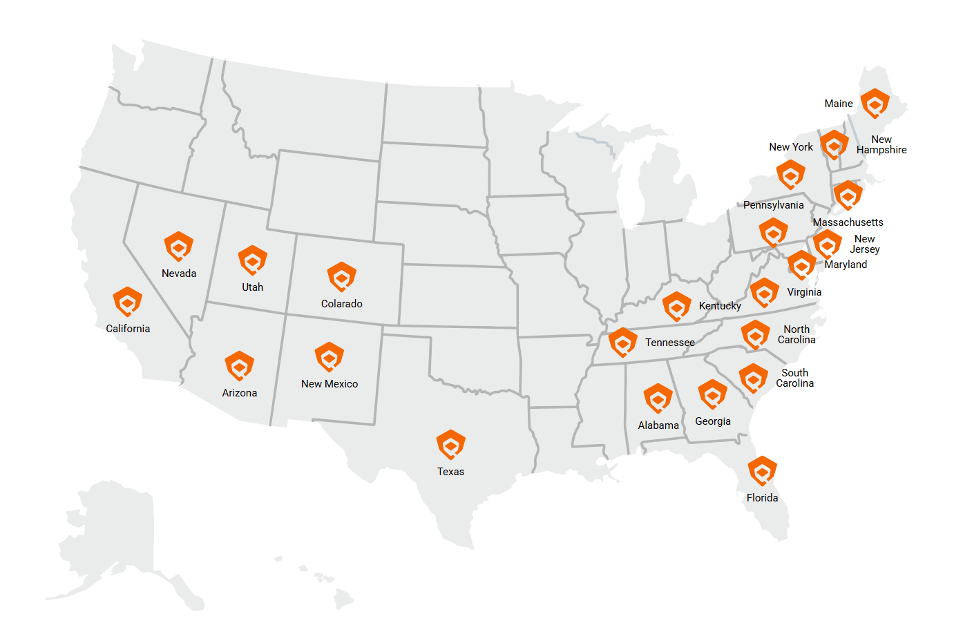
Charleston-based. Nationwide capable.
Field teams deploy regularly from Charleston, SC across the Southeast as the primary service area, with proven mobilization to projects nationwide for portfolio and modernization-scale programs.
- On-site field capture services
- Regional project support
- Subcontractor support to A/E/C firms
- Remote data processing and digital modeling
Ready to discuss your next requirement?
Direct lines for acquisition teams, contracting officers, and prime contractors. Capability statement, NAICS matrix, and federal past-performance references provided on request.
Charleston, SC 29403
- Formal capabilities statement (PDF)
- Detailed past-performance references
- NAICS / PSC matrix and rate guidance
- Sample deliverables (BIM, CAD, point cloud)
- Teaming agreement discussions